

Create geo pdf does not work

Copy link to clipboard
Copied
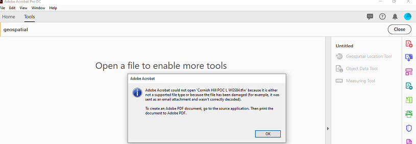
I have tried to create a geo pdf by using the Acrobat DC File > Create > PDF from file > and giving the file name of a geospatial TIFF file. The latter is associated with its .tfw file containing geospatial info.
The TIFF image was successfully imported (except in the case of UTM which does not used degrees/minutes) WGS84 is specified as the geodetic datum and I have tried various projection co-ordinate systems including UTM with dec degrees, Popular Visualisation CRS/Mercator as used by Google, Pseudo Mercator. A Swiss based cartographer tried it also with a geospatial TIFF file he had and again the TIFF file was imported but not the geospatial info.
Trawling through the skimpy Acrobat DC info on this process, gave little indication of what co-ordinate systems are acceptable. WGS84 is stated as a (the?) datum. The Acrobat file Preference of Measuring (Geo) s indicates degrees are to be used.
Can anyone throw further light on this please? You can download the relevant TIFF files from Dropbox - Acrobat geo pdf files


 13
Replies
13
13
Replies
13

Copy link to clipboard
Copied
This is very interesting. It s my first time learning all this. Never had a clue Adobe was also used for this purpose until now, and I find it fascinating.
I recreated in my Acrobat your scenario following the steps described here:
Geospatial PDFs, Adobe Acrobat
But I see the same problem
It mentions a specific step about how to incorporate the shape file, which from what I am gathering is the TIFF file in question.
Maybe changing the file format from TIFF to JPEG2000 will do the trick?
And then import as layer the original pdf file using this new jpeg2000 file format for the shape file?
Copy link to clipboard
Copied
Thank you for your response ls_rbls.
I don't create the TIFF from a Shape file but from a cartographic software. It seems the purpose of the Shape file import facility is simply to add a further information layer to the PDF.
My cartographic software does not export JPEG 2000. TIFF being lossless would provide the highest resolution.
The TFW world file is very simple so I am unsure as to how it could be misinterpreted by Acrobat. Maybe the pixel size is out of range for Acrobat yet there is no indication in the online or guide info on such a limitation.
I have just 2 days left of my DC trial so looks like I'll be back to my trusty Acrobat X.
Copy link to clipboard
Copied
Just tried geo TIFF export from another cartographic software and again ended up with a non geo pdf.
Copy link to clipboard
Copied
Is the export file for the same geospatial files that you provided above?
So far the three files that you provided earlier are :
Cornish Hill POC L WGS84 Pop Vis Mercator.pdf
Cornish Hill POC L WGS84.TIF
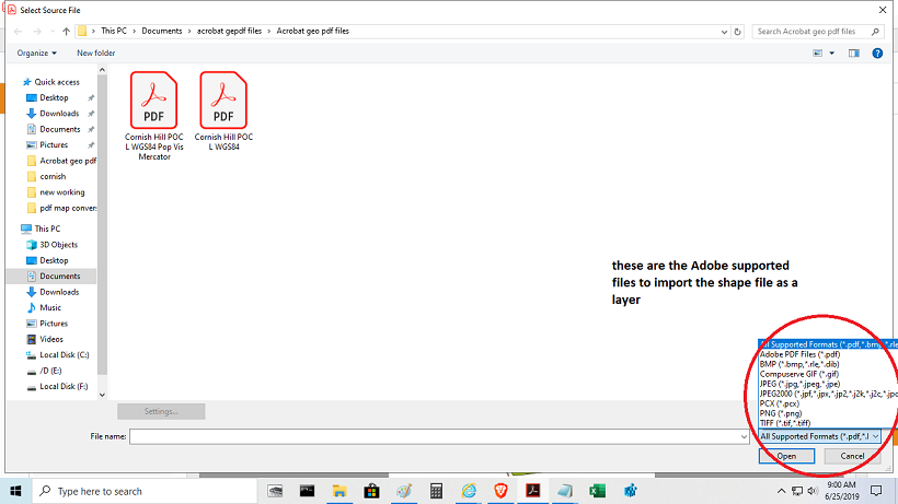
Cornish Hill POC L WGS84.tfw <--------------------------------- is this supposed to be the shape file??
If it is , I tried converting the file to a format that can be accepted by Adobe, such as, the ones shown in the bottom right corner of this slide but the second slide show what I get in return

I normally use IrfanView as my main application to convert files of any type. It is supposed to be a very robust platform to this type of file conversions. So I went ahead and tried to import in Adobe.
When trying to import to Adobe the same message; that is two different applications displaying the same information about this particular file.
I also went to the Microsoft App store and they don't have a program available there that would , could or should associate this type of file to work with it.
I am thinking that, maybe, when the file was georeferenced from the original software it needed to be saved as a shape file in another file format rather than tfw? (ahpe file in DFX format, then convert it to JPEG2000 or TIFF. )
Based of what I am reading when the shape file is exported into JPEG2000 or TIFF it is supposed to retain all of the geospatial data during export/import procedures into the PDF editor.
As you can see below, I was able to import as layers the first two files that you provided above

But when trying to import this "tfw" file into pdf no luck and I am not able to get coordinates.
See if you can georeferenced the shape file in TIFF
Copy link to clipboard
Copied
I forgot to add this slide which shows where I got stuck during the procedures mentioned above:
Copy link to clipboard
Copied
You mentioned the shape file cannot be created in TIFF from the cartographic software but then we might need to find a tool that can convert it to TIFF at the most
Copy link to clipboard
Copied
I also forgot to ask which cartographic software did you used to produce the shape file?
Copy link to clipboard
Copied
So I downloaded and installed GQIS 3.8 Zanzibar (latest version) which is free.
After installing it I found this video in youtube that is very useful in showing how to perform a file conversion with this software form TIFF to GeoTIFF (setting on a "tfw" value before running the conversion script)
h t t p s://www.youtube.com/watch?v=UmUBS2qxBA8
I also downloaded and tried ImageStationRaster Utilities which allows to do a file conversion from any raw formatted file into other formats.
Both programs I've found to be as highly technical as educational but nonetheless very easy to get started with in a short amount of time.
You can deploy GQIS in Windows, Mac, Linux, BSD and Android.
This is all new to me but you might find these application helpful with cartographic features.
Best of luck, and post back if any of these worked. I am curious to know if the file corrupt, infected by a virus or everything is as knowing which tool to use to convert the file in order to import as layer in Adobe.
Copy link to clipboard
Copied
Thanks for your effort ls_rbis. Firstly, a shape file is irrelevant to the situation as that function is simply an optional extra in DC.
Secondly, when I ran QGIS (not GQIS 🙂 as reported earlier, it produced a TFW file as expected and Acrobat DC still failed to produce a geo pdf.
So I have used two cartography softwares (QGIS and a proprietary s/w) on two different map files and a colleague has used the proprietary software with a Swiss topo file as input. All delivered a null result through Acrobat DC.
Conversion utilities are not relevant to my situation as my original data is in my proprietary software (or QGIS) and thus I need to export a geospatial TIFF from there to get Acrobat DC to process that into a geo pdf which wil then be used on AVENZA map platform. I know for certain the TIFF/TFW files I produce are correct as I use them frequently as input to other map related softwares that require georeferenced files.
Again I appreciate your extensive effort ls_rbis. But at this late stage of my DC trial I won't be exploring further.
Copy link to clipboard
Copied
Well, this was good learning experience for me. And thanks for your patience.
By the way, I know that your trial is expiring soon, but I did found something that for future reference might help in other areas not necessarily related to your case:
I added the TerraGo toolbar to Adobe Acrobat Pro, it seems to complement a lot of the things you have mentioned..
I am posting the URL below in case other adventurer users find this post useful, (like myself) 
h t t p:/ / info.terragotech.com/Video/TerraGo-Toolbar-Installation
Anyway, from what I continued to read it seems like the georegistration tools were removed after Adobe Acrobat 9.
So I went to the Avenza website, and found there that using the MAPublisher in combination with Adobe Illustrator is key to this process; Exporting from Avenza to Adobe Illustrator and from Adobe Illustrator to Adobe Acrobat .
Most of the questions that I found to be answered to the users around these forums are marked as "correct answer" when the only answer available suggest to the users to submit a bug report; I don't personally agree with that... but Ok, what can you do right?
In my very personal opinion, it seems like the GPS market and other agencies have acquired the right to control what can be used or not in Adobe when it comes to geospatial reference .
It just baffles me that after so much research to find out that in earlier versions of Adobe Acrobat georeferencing was possible just as easy as clicking on a spot in the map or by entering the referenced coordinates yourself.

Copy link to clipboard
Copied
I tried several of my Geotiffs, and converted some from other projections to WGS84, with no luck in Acrobat Pro (2017) itself. They have all the .tfw (World) file for positioning the .tif on its correct place. Jpeg2000 (.jp2) images have a .jw2 file instead.
So with Qgis 3.8 you can convert a GeoTif directly to a geospatial .pdf, if you open it and begin to measure in Acrobat (first click is needed), you will get geo-coordinates and lengths.
Arcmap (10.6) cannot perform this conversion, but can create a Layout print where it puts the correct georeferencing in it, so you can georeference every map you create (as long as the main reference is WGS84 or EPSG:4326 .
As Qgis seems not be able to create georeferenced maps from the layout, both programs do complement each other in this case.
I do not think that this is some mapping software company scheme, but just an annoying bug in Acrobat. The function isn't used that much, and most companies that use mapping software aren't interested in a bugfix, because they don't know.
Copy link to clipboard
Copied
Hi!
It seems like some georeferencing software vendors are adding capabilities to work around it.
I tried to play around with GRASS a few months after this thread. At the time I didnt know how to figure it out.
But now it have georectifier add-ons and reprojection modules to work around scanned maps
Copy link to clipboard
Copied

Find more inspiration, events, and resources on the new Adobe Community
Explore Now
 AdChoices