Copy link to clipboard
Copied
My camera can GEO Tag photos it takes. Can Elements 2018 read this and automatically install on the map? If so, how? Currently what I do is select the photos (in Organizer) to be placed on the map and select the "add location" icon. However this isn't that accurate (or at least I can't figure out how to male it accurate). For example if I take photos of a park in my home city and then type in that city when asked I can't pinpoint where the photo was taken. Is there a way to move the icon in Places view once its placed or does the program simply place the photos in the center of the city? Any help is appreciated. Thanks.
Copy link to clipboard
Copied
If the camera adds gps data when the photo is taken it should appear automatically on the map. You can view the co-ordinates by expanding the metadata panel in the info tab – see image below.
Copy link to clipboard
Copied
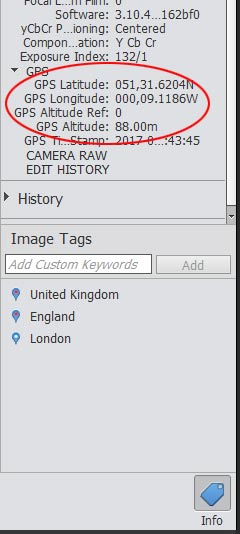
If the photos have GPS data, click on Places in the top of Organizer, and then you will see all the tagged photos on the left panel. On the right panel Map you can zoom in and see all the locations with photos.
You can also use the Media button on top of Organizer and Tags panel on the right, on the Places on the right (scroll to bottom) you will see the details of your tagged places. Works very well.
Copy link to clipboard
Copied
Thanks for the helpful responses. I've since figured out how to move points on the map (unpin). This forum and utube searches are great. I'm still learning Elements and Premiere Elements (just got it Tuesday). Prior I only used Lightroom.