

Adding GPS data to photos from a tracklog

Copy link to clipboard
Copied
What is the best way to add the GPS data contained in a tracklog file (in my case from a Garmin handheld device) to my Lightroom photos?


 7
Replies
7
7
Replies
7

Copy link to clipboard
Copied
I, too, am interested in knowing this.

Copy link to clipboard
Copied
Lightroom 4.x has a Map module that will do this, I think, depending on exactly what you want. I don’t use it so I cannot tell you what the limitations might be.
I’ve been using the free GeoSetter to do this long before LR could and continue to use it: (Edited by Moderator. Link is no longer valid)
(This link will redirect to the English-language version of a German site because the author is German.)

Copy link to clipboard
Copied
Please be careful with ssprengel's link. It goes to a phishing site. (Probably didn't when he posted it but now it does.)
Copy link to clipboard
Copied
Yes, the link used to work 2 years ago when I posted it, but someone evil has taken over the domain, probably after the original user quit paying for it.
The native German site is and has always been www.geosetter.de with the English-language version: www.geosetter.de/en which is where the .com version redirected, originally.
The home page should look something like this:


Copy link to clipboard
Copied
Select the images you want to geoencode, switch to the Map module, choose Map/Tracklog/Load Tracking (Choose the tracklog file), and choose Map/Tracklog/Auto-tag Photos. I don't believe it's absolutely necessary to download the tracks first. Instead you can connect the GPS device in mass storage mode and download directly to LR4. Edit: I checked my Garmin and it doesn't seem to have a way to switch to mass storage mode. So you need Garmin's software or something like Easy GPS or Geosetter to download tracks and save them as .gpx files.
I still prefer using Jeffrey Friedl's Geoencoding Support plug-in to do the encoding and Easy GPS to download and save the tracks from my Garmin eTrex Vista HCx.

Copy link to clipboard
Copied
Lightroom does support .GPX format of tracklog file.
In Lighroom 4.x under Map module you can load tracklog from third party device.
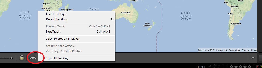
Click the GPS Tracklogs button and choose Load Tracklog to upload GPS data (a GPX file) from a third-party device.
It will give you GPS data based on tracklog and let you thesse data to Photos.
For more information on working with GPS data please check following help article.
Copy link to clipboard
Copied
How to add GPS data to your photos (Windows centric instructions).
1. Save the tracklog (.gpx) file from your GPS unit. For example, for a Garmin you can use their BaseCamp® software (see your GPS unit's documentation).
2. In Lightroom 4 (LR4), navigate to the Map module.
3. On the main menu click Map, point to Tracklog, and then, on the flyout menu, click Load Tracklog...
4. Navigate to where you saved your .gpx file and select it. Click Open. LR4 will load your .gpx and display the track.
5. Return to the Library module and select the photos you want to tag with GPS data.
6. Return to the Map module. On the main menu click Map, point to Tracklog, and then, on the flyout menu, click Auto-Tag X Selected Photos...
That should do the job, provided that you have synchronized the time/date on your camera to match your GPS unit prior to shooting. Happy tagging. Zander.

 AdChoices