

- Home
- Lightroom Classic
- Discussions
- Re: Map Module - it's not Birdseye View rather tha...
- Re: Map Module - it's not Birdseye View rather tha...
Map Module - it's not Birdseye View rather than Oblique?

Copy link to clipboard
Copied
The Map Module doesn't seem to have an option for just an oblique view of the satellite imagery. Now it looks like Bing's Birds-eye View.
I'm trying to drag images to a particular street intersection (I don't know the exact address) and the attached screenshot makes it a bit difficult.
What am I missing?


 19
Replies
19
19
Replies
19
Copy link to clipboard
Copied
Can you not edit your posts on the Adobe forums??

Copy link to clipboard
Copied
Not sure about the original post, but you can definitely edit your replies.

Copy link to clipboard
Copied
Maybe becasue I'm a noob...

Copy link to clipboard
Copied
@oweniverson wrote:
Maybe becasue I'm a noob...
That might be correct if you mean you haven’t made many forum posts on this site. Although I don’t know all the details about how they program it, my understanding is that post editing is enabled for users with solid histories of valid posts, and not posting spam. I don’t know how they set the threshold for that, how many posts you have to have before they let you edit.
I just know that comment spam is a huge problem on many forums across the web, and one spammer tactic is to post an “innocent” post, then after it’s approved, they edit in their spam link. So, many forums have tried to defend against that by restricting editing except for very trusted users.
Copy link to clipboard
Copied
I don't know that you're "missing" anything. That's just the way Google Maps displays some areas as you zoom in. My only suggestions are to zoom out a little or switch the Map Style from Satellite to Road Map.
Copy link to clipboard
Copied
Maybe Bing does, but Google doesn't.
Google can, but it's not a default.
I guess yeah, standard map is the way to go. Just struck me weird not being able to see oblique satellite imagery.
Copy link to clipboard
Copied
Google Maps seems to default to that view for me...

Copy link to clipboard
Copied
Whoops, I just noticed that your map screenshot is actually in Google Maps full Globe/3D view, not the one I was showing/thinking. I've had that happen to me before too. I've been able to get out of it in LrC by some combo of opening Google Maps in my browser and making sure I turn off Globe View on the Satellite layer and/or clearing my browser cache & cookies. I don't know the particulars, but my guess is there's a shared setting somewhere that all Google Maps are using.

Copy link to clipboard
Copied
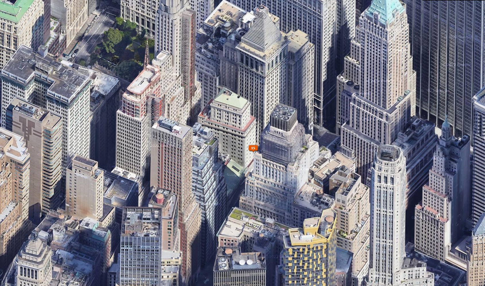
Since a few days LrC Map module past a certain zoom level switches to the (horrible) Bird's Eye View, something that makes precise positioning of photos not possible anymore. Try this: put the pin where the new visualization makes you believe it's correct, then copy the coordinates and look in the real web version of Google Maps. You'll see a position very different, at least by 15/20 meters.
As my workflow requires PRECISE GPS, this is a new and really disturbing bug, the makes one of the most useful features of LrC totally a joke.
Please!! Revert to the old version!

Copy link to clipboard
Copied
[This post contains formatting and embedded images that don't appear in email. View the post in your Web browser.]
My LR 11.3.1 Map module (both Mac and Windows) shows a Google 2D satellite view for that location (around 14 Wall St, New York), while yours is showing a Google Global (3D) view. Someone else reported similar symptoms a couple weeks ago but never followed up on whether they went away. Since not everyone sees the Global (3D) view, I think this is a bug affecting some rather than a deliberate change affecting everyone.
Here's my LR 11.3.1 Map for 14 Wall St:

And zoomed all the way in:

Copy link to clipboard
Copied
Also, until someone can produce a step-by-step recipe that lets other reproduce the problem or until many people report it, it's unlikely it will get attention from Adobe, unfortunately.
Copy link to clipboard
Copied
Moderators, @Rikk Flohr: Photography, please merge with this existing thread describing very similar symptoms:

Copy link to clipboard
Copied
Same problem here: LR Classic 11.3.1 on MacOS 12.3.1.
Hope there will be a fix soon.

Copy link to clipboard
Copied
So in last few months salellite/hybrid map view has changed from top view to some kind of perspective.
Its bad for me for at least two reasons:
- perspective view got much older maps - at least 5 years old
- its hard to add pin to locations behind buildings
Is there a way to change satellite map view to top view?
Copy link to clipboard
Copied
A few others have reported this bug in the last couple of months. It could be a bug in the way LR is calling Google's map service, or it could be purely a bug on Google's side. But without a reliable way to reproduce the problem on multiple configurations, Adobe won't pay much attention unless many, many people report the problem, unfortunately.
Copy link to clipboard
Copied
Moderators, @Rikk Flohr: Photography, please merge with the existing thread:
Copy link to clipboard
Copied
Insteresting, now my map module cant load at all. Its all gray or its showing error msg.

Copy link to clipboard
Copied
Even better, after reopening my Lr once again - map module works normally like always. Maybe someone menaged to fix it?
(i cant edit my post?)

Copy link to clipboard
Copied
Right now, if you close Lightroom Classic with the map module showing, you will get errors in the map module when you next launch Lightroom Classic. If you close Lightroom Classic from the Library or Develop modules and later launch Lightroom Classic, then the map module works properly.

Get ready! An upgraded Adobe Community experience is coming in January.
Learn more
 AdChoices