

- Home
- Photoshop ecosystem
- Discussions
- Re: lost coordinate of .tif image when edit by psc...
- Re: lost coordinate of .tif image when edit by psc...
lost coordinate of .tif image when edit by pscs6

Copy link to clipboard
Copied
hi all,
i have lost coordinate of .tif image when edit by pscs6. Could y help me?


Explore related tutorials & articles
 17
Replies
17
17
Replies
17

Copy link to clipboard
Copied
Can you expand what is the issue?
Copy link to clipboard
Copied
Hi Derek,
I have a file .Tif image. I can import this image to autocad with right position on map, when I edit this image by PSCS6 then I cannot import it right position again. It seem lost coordinate of my image.
Thanks
Copy link to clipboard
Copied
Hi Derek,
I have a image .Tif. I can import it into Autocad with right position on map. But when I edit it by PSCS6 then i can not import right position again. It seem lost coordinate in my image.
Thanks

Copy link to clipboard
Copied
Sounds as if the original image has GPS metadata that is used in AutoCad, however once the same image is edited in CS6 the metadata is either altered or removed. Can you post a download link to before/after image samples on a file sharing site such as DropBox or similar?
Copy link to clipboard
Copied
Thanks Stephen,
Images sample as link :https://drive.google.com/open?id=1ojHmveXpVMW0Z3pbk6PhWrDG-L9atZQd
https://drive.google.com/open?id=1ojHmveXpVMW0Z3pbk6PhWrDG-L9atZQd
Copy link to clipboard
Copied
Yes, Photoshop is stripping the metadata, ExifTool reports that the following tags are removed even in CC2018:
[GeoTiff] GeoTiffVersion : 1.1.0
[GeoTiff] GTModelType : Projected
[GeoTiff] GeographicType : WGS 84
[GeoTiff] ProjectedCSType : User Defined
[GeoTiff] ProjCoordTrans : Transverse Mercator
[GeoTiff] ProjLinearUnits : Linear Meter
[GeoTiff] ProjNatOriginLong : 106
[GeoTiff] ProjNatOriginLat : 0
[GeoTiff] ProjFalseEasting : 500000
[GeoTiff] ProjFalseNorthing : 0
[GeoTiff] ProjScaleAtNatOrigin : 0.9996
There are various tools which can copy GPS metadata from original files or otherwise enter some of this data into the files saved from Photoshop.
Copy link to clipboard
Copied
Thanks Stephen,
Could you tell me the name of tool can do that? I hope i can download
Copy link to clipboard
Copied
I personally would use ExifTool, however there may be other options out there that you may prefer… I’d recommend a Google search.
Test on a single duplicate image or remove the -overwrite_original argument if you are not working on duplicates or have no backups.
Using your sample files as an example, to copy all of the original metadata to the edited file you would use the following command line code:
exiftool -overwrite_original -TagsFromFile Before.tif After.tif
However in practice you will likely need to specify a full path to the images unless you are going to use the CLI to navigate to the working directory:
exiftool -overwrite_original -TagsFromFile '/Users/<username>/Desktop/Before.tif' '/Users/<username>/Desktop/After.tif'
Note: Windows users would need to use double straight quote marks to enclose a file or directory path name rather than single straight quotes.
This is just an introduction, there are refinements that could be made – for example depending on how many images you need to process you may need to update in batches.
Copy link to clipboard
Copied
Many thanks Stephen,
Your information is very important to me, I will try to learn more about Exlftool.
Copy link to clipboard
Copied
HI Stephen,
I can process metadata successful in Exiftool. But after that, when i input into Autocad, the coordinate not appear.
Do you know why?
Copy link to clipboard
Copied
Can you post a link so that I can check the ExifTool processed image?
Copy link to clipboard
Copied
Hi Stephen,
My image after edit and process by Exiftool as link below:
https://drive.google.com/open?id=1W1ygkJnJ366-vR3Pyqxg3fvS5HWCkSSg
Copy link to clipboard
Copied
I don’t know why the geotif data is not being picked up, it is in your updated file so we can probably rule out user error in updating the metadata.
I doubt that the following file will work, but give it a go and report back (I have removed the xmp and photoshop metadata entries which were not in the original file that worked):
https://www.dropbox.com/s/qr1ulr1le8qtyr7/After-xmp-photoshop.tif?dl=0
Copy link to clipboard
Copied
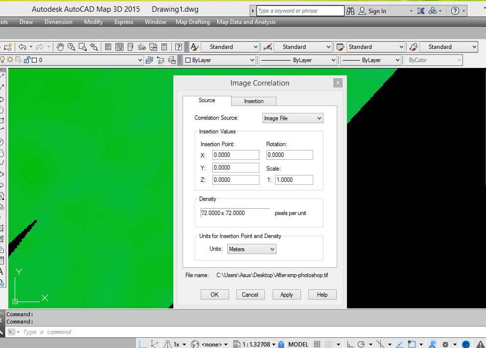
Hi Stephen,
This images from you still have no coordinates. 
Copy link to clipboard
Copied
Too bad, you’ll need to look at other software then. Please let the forum know if you have success.

Copy link to clipboard
Copied
Maybe it’s not in the file at all but in a TFW file you have to provide. Exercise P5: Using a World Correlation File | AutoCAD Raster Design 2019 | Autodesk Knowledge Networ...

Copy link to clipboard
Copied
I use listgeo & geotifcp to extract then reinsert the geotiff metadata.
https://download.osgeo.org/geotiff/libgeotiff/listgeo-geotifcp-win32-x86-112502.zip
listgeo inputfile > metadata
geotifcp -g metadata input output

Find more inspiration, events, and resources on the new Adobe Community
Explore Now
 AdChoices