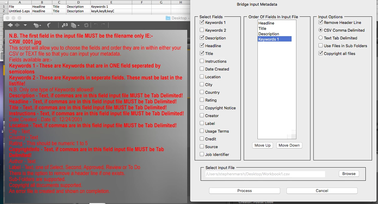
Copy link to clipboard
Copied
I am very new to working with metadata. I have a microsoft excel file with the IPTC Core fields I need for each image file.
(Creator, Headline, Description, Keywords, Title, Job Identifier, Credit Line, Source, Rights Usage Terms, Copyright Status and Copyright Notice)
Is there a way to get the metadata into the files without having to copy from a cell into each metadata field individually?
I am hoping some for sort of script, possibly...
Also, if only ONE of these fields needed updating in all of the files (i.e. Rights Usage Terms) can that be done?
I have Bridge 5.1 (and earlier versions CS3/CS4)
Perhaps try tab delimited format instead of comma separated value format.
Edit – Paul Riggott originally wrote the following instructions:
...
N.B. The first field in the input file MUST be the filename only IE:- CRW_0001.jpg
This script will allow you to choose the fields and order they are in within either your CSV or TEXT file so that you can input your metadata.
Fields available are:-
Keywords 1 - These are Keywords that are in ONE field seperated by semicolons
Keywords 2 - These are Key
Copy link to clipboard
Copied
Lumigraphics Yes presentationPath can be a bummer
You are missing the namespace to enter the Exif details so it would put the details into fiels associated with the drone fields
Enter:
md.namespace = "http://ns.adobe.com/exif/1.0/";
Before the line:-
md.GPSLatitude = '';
The namespace directs what schema you are addressing.
Hope this helps.
Copy link to clipboard
Copied
I made that change and it closed Bridge when I ran the script. I will try it again later and check it to make sure I did not make an entry error. I looked close and it all seemed correct.
var thumb = new Thumbnail(file);
md = thumb.synchronousMetadata;
if(thumb.hasMetadata){
md.namespace = "http://www.dji.com/drone-dji/1.0/";
md.RtkFlag = '';
md.RtkFlag = Flag;
md.RtkStdLon = '';
md.RtkStdLon = StdLon;
md.RtkStdLat = '';
md.RtkStdLat = StdLat;
md.RtkStdHgt = '';
md.RtkStdHgt = StdHgt;
md.namespace = "http://ns.adobe.com/exif/1.0/";
md.GPSLatitude = '';
md.GPSLatitude = Lat;
md.GPSLongitude = '';
md.GPSLongitude = Lon;
md.GPSAltitude = '';
md.GPSAltitude = Hgt;
}else{
Copy link to clipboard
Copied
That looks good. I forgot to say that a restart of Bridge is required if any changes are made to a script.
Copy link to clipboard
Copied
SuperMerlin, My GPS data is still not getting updated. I wanted to double check and make sure the namespace for the [composite] section was not supposed to be something else.
I also discovered that my data has some differences. I had the ° symbol after Degrees where the existing data in the EXIF has " deg " following the degrees. This is for Lat and Lon.
Also my Altitude is 148.931 (3 decimal places). The existing data in EXIF is whole number only (no decimals) and it contains the text " m Above Sea Level" after the altitude.
So i am going to alter my CSV file to reflect the same format and see if it will accept it. Any insight will be appreciated. My CSV file did have Dec Degrees and I have since converted that to DMS. Now I just need to fix the other minor formatting details.
Below is existing EXIF data that has not yet been updated.
-------------------------------------
[Composite] Aperture: 5.6
[Composite] CircleOfConfusion: 0.011 mm
[Composite] DOF: inf (0.00 m - inf)
[Composite] DateTimeCreated: 2018:12:22 13:00:29
[Composite] FOV: 73.7 deg
[Composite] FocalLength35efl: 8.8 mm (35 mm equivalent: 24.0 mm)
[Composite] GPSAltitude: 148 m Above Sea Level
[Composite] GPSLatitude: 34 deg 57' 6.74" N
[Composite] GPSLongitude: 89 deg 55' 48.98" W
[Composite] GPSPosition: 34 deg 57' 6.74" N, 89 deg 55' 48.98" W
[Composite] HyperfocalDistance: 1.26 m
[Composite] ImageSize: 4864x3648
[Composite] LightValue: 13.3
[Composite] Megapixels: 17.7
[Composite] ScaleFactor35efl: 2.7
[Composite] ShutterSpeed: 1/320
Copy link to clipboard
Copied
If these “composite” tags have come from inspection with ExifTool, it should be noted that they are indrect “computed” tags that are generated on the fly from existing metadata and are not directly available in the file.
Copy link to clipboard
Copied
i was viewing the metadata export with MetaData++. Now I am using ExifGUI. The first program shows the GPS coordinate as DMS (degrees minutes seconds), BUT Exif GUI shows a complete section for GPS and it shows the GPS coordinates as Decimal Degrees.
So my question is how do I confirm what the actual data is in the images Exif? I also need to figure out how to write the GPS data back to the image because that seems to be failing.
Data shown by ExifGUI
--------------------
---- EXIF ----
Image Description : DCIM\100MEDIA\DJI_0002.JPG
Make : DJI
Camera Model Name : FC6310
Orientation : Horizontal (normal)
X Resolution : 72
Y Resolution : 72
Resolution Unit : inches
Software : v01.07.1641
Modify Date : 2018:12:22 13:00:29
Y Cb Cr Positioning : Centered
Exposure Time : 1/320
F Number : 5.6
Exposure Program : Program AE
ISO : 100
Exif Version : 0230
Date/Time Original : 2018:12:22 13:00:29
Create Date : 2018:12:22 13:00:29
Components Configuration : -, Cr, Cb, Y
Compressed Bits Per Pixel : 3.185197909
Shutter Speed Value : 1/320
Aperture Value : 5.6
Exposure Compensation : 0
Max Aperture Value : 2.8
Subject Distance : 0 m
Metering Mode : Center-weighted average
Light Source : Daylight
Flash : No flash function
Focal Length : 8.8 mm
Flashpix Version : 0010
Colour Space : sRGB
Exif Image Width : 4864
Exif Image Height : 3648
Interoperability Index : R98 - DCF basic file (sRGB)
Interoperability Version : 0100
Exposure Index : undef
File Source : Digital Camera
Scene Type : Directly photographed
Custom Rendered : Normal
Exposure Mode : Auto
White Balance : Auto
Digital Zoom Ratio : undef
Focal Length In 35mm Format : 24 mm
Scene Capture Type : Standard
Gain Control : None
Contrast : Normal
Saturation : Normal
Sharpness : Hard
Subject Distance Range : Unknown
Serial Number : d3ea87f35e1f17805c95a554bba186a4
GPS Version ID : 2.3.0.0
GPS Latitude Ref : North
GPS Latitude : 34.951873°
GPS Longitude Ref : West
GPS Longitude : 89.930273°
GPS Altitude Ref : Above Sea Level
GPS Altitude : 148 m
GPS Processing Method : MANUAL
XP Comment : Type=N, Mode=P, DE=None
XP Keywords : v01.07.1641;1.2.0;v1.0.0
Compression : JPEG (old-style)
X Resolution : 72
Y Resolution : 72
Resolution Unit : inches
Thumbnail Offset : 10240
Thumbnail Length : 10203
Thumbnail Image : (Binary data 10203 bytes, use -b option to extract)
Copy link to clipboard
Copied
As I said before use Bridge - File Info - Raw Data
This will show what the correct format is. Do not use anything else!
Copy link to clipboard
Copied
Sorry I missed that :0 Viewing FILE INFO>RAW DATA in Bridge is VERY helpful.
Copy link to clipboard
Copied
The script is only putting in data that is in the CSV file so no altarations are being made.
To see actual fields and what is required in your csv file you need to check your file with Bridge - File Info - Raw Data
There you will find the format that is required.
As Stephen has said the composite fields do not exist and are generated by the program you are using to read the data.
Copy link to clipboard
Copied
Good afternoon. I tried to mod this code myself and I am having trouble. I found out that I need to also update the GPS data for the EXIF block as well as the XMP block. I looked to see if I made a typo and do not see one. I don't know if I have to do something different for two different namespaces. Would you mind looking at my edits and see if you see my error?
Line changes
03. Changed name in Line 3 (added V2 to give me second menu option)
18. Added trim(p[8]),trim(p[9]),trim(p[10])
30. Added ExLat,ExLon,ExAlt to reference new fields (Exif Latitude, Exif Longitude, Exif Altitude
54-60 Added Adobe Namespace reference and additional fields. I have GPS all caps as that is how they are in the existing Exif Data.
When I run this in Bridge, it just sits there for 1-2 seconds and then Bridge closes.
#target bridge
if( BridgeTalk.appName == "bridge" ) {
var drone = new MenuElement( "command", "Drone Metadata V2", "at the end of Tools" );
}
drone.onSelect = function () {
var csvFile = File.openDialog("Open Comma-delimited File","comma-delimited(*.csv):*.csv;");
if (!csvFile.exists) return;
csvFile.open('r');
var data = csvFile.read().split("\n");
csvFile.close();
var line = new Array();
for(var a in data){
var Q = data.toString();
if(Q.length > 2) line.push(Q);
}
for(var z in line){
var p=line
.split(','); droneMetadata(trim(p[0]),trim(p[1]),trim(p[2]),trim(p[3]),trim(p[4]),trim(p[5]),trim(p[6]),trim(p[7]),trim(p[8]),trim(p[9]),trim(p[10]));
}
alert("Batch complete\nDrone Error Log on Desktop\n If any errors occured");
function trim(s){
return s.replace(/^\s+|\s+$/,'');
}
function log(message){
var errorLog = File(Folder.desktop + "/Drone Error Log.txt");
errorLog.open("a");
errorLog.writeln(message);
errorLog.close();
}
function droneMetadata(th,Flag,StdLon,StdLat,StdHgt,Lat,Lon,Hgt,ExLat,ExLon,ExAlt){
var file = new File(new Folder(app.document.presentationPath)+ '/' + trim(th));
if(!file.exists){
log("File does not exist! " + trim(th));
return;
}
var thumb = new Thumbnail(file);
md = thumb.synchronousMetadata;
if(thumb.hasMetadata){
md.namespace = "http://www.dji.com/drone-dji/1.0/";
md.RtkFlag = '';
md.RtkFlag = Flag;
md.RtkStdLon = '';
md.RtkStdLon = StdLon;
md.RtkStdLat = '';
md.RtkStdLat = StdLat;
md.RtkStdHgt = '';
md.RtkStdHgt = StdHgt;
md.GpsLatitude = '';
md.GpsLatitude = Lat;
md.GpsLongitude = '';
md.GpsLongitude = Lon;
md.AbsoluteAltitude = '';
md.AbsoluteAltitude = Hgt;
md.namespace = "http://ns.adobe.com/exif/1.0/";
md.GPSLatitude = '';
md.GPSLatitude = ExLat;
md.GPSLongitude = '';
md.GPSLongitude = ExLon;
md.GPSAltitude = '';
md.GPSAltitude = ExAlt;
}else{
log("Cannot write metadata to " + decodeURI(thumb.spec));
}
};
};
First Lines of CSV file
DJI_0002.JPG,50,0.008,0.007,0.017,34.95187873,-89.93024736,+148.931,34.95187873,-89.93024736,+148.931
DJI_0003.JPG,50,0.008,0.007,0.017,34.95181193,-89.93017817,+149.19,34.95181193,-89.93017817,+149.19
DJI_0004.JPG,50,0.008,0.011,0.015,34.95176096,-89.93012334,+149.67,34.95176096,-89.93012334,+149.67
DJI_0005.JPG,50,0.008,0.006,0.015,34.95170888,-89.93005634,+149.769,34.95170888,-89.93005634,+149.769
DJI_0006.JPG,50,0.008,0.006,0.015,34.95165501,-89.92998616,+149.653,34.95165501,-89.92998616,+149.653
DJI_0007.JPG,50,0.008,0.007,0.016,34.95154082,-89.92984514,+149.955,34.95154082,-89.92984514,+149.955
DJI_0008.JPG,50,0.012,0.019,0.016,34.95148343,-89.92977355,+150.012,34.95148343,-89.92977355,+150.012
DJI_0009.JPG,50,0.008,0.007,0.016,34.95142627,-89.92969896,+149.788,34.95142627,-89.92969896,+149.788
DJI_0010.JPG,50,0.008,0.007,0.016,34.95136721,-89.92962243,+149.572,34.95136721,-89.92962243,+149.572
DJI_0011.JPG,50,0.008,0.006,0.015,34.95130963,-89.92954778,+149.635,34.95130963,-89.92954778,+149.635
DJI_0012.JPG,50,0.008,0.007,0.017,34.95126481,-89.92948684,+149.564,34.95126481,-89.92948684,+149.564
Copy link to clipboard
Copied
I know next to nothing about the GPS format, it looks as if ExifTool might be changing the format for you but the format is incorrect for Bridge.
<exif:GPSLatitude>52,23.5884N</exif:GPSLatitude>
<exif:GPSLongitude>12,36.3339E</exif:GPSLongitude>
<exif:GPSAltitudeRef>0</exif:GPSAltitudeRef>
<exif:GPSAltitude>165779/1000</exif:GPSAltitude>
As you can see Bridge uses it's own format for GPSLatitude and GPSLongitude
It also requires GPSAltitudeRef 0 for above sea level 1 for below sea level
The GPSAltitude needs to be in the above format.
I could possibly code the above changes if you could let me know what the GPSAltitute is I.E feet/meters etc.
Copy link to clipboard
Copied
The altitude will always be in meters.
I am pretty sure that the adobe script will take this format from a CSV file but I'm not 100% sure.
<exif:GPSLatitude> 52.393140
<exif:GPSLongitude> 12.605566
<exif:GPSAltitude> 165.779 m
The format of the actual data above (ie 52.393140) is the format being updated by ExifTool. So I am not sure if Bridge will accept that data and then "auto convert" it?? I just don't know.
This tag already exists and does not need to be added in. It in almost all cases be 0
<exif:GPSAltitudeRef> 0
The data in my CSV file is in Decimal Degrees xx.xxxxxxxx. I found a script that a guy wrote for converting it from Decimal Degrees to the Adobe format for Bridge.
Re: Entering GPS data into Bridge in the correct format
Would that script be helpful?
I am trying to come up with 2 methods that this can be used to makes these updates for folks doing drone mapping (one using ExifTool and one using Bridge). The ExifTool option is now working very nicely. The Bridge script you wrote was working nicely but then I found out that I must update the GPS data in the EXIF block as well as adding it to the XMP-dji-drone block.
Copy link to clipboard
Copied
Oh dear, its my fault! I was rushing to create the script. The problem I suspect is that the file names have a space in them and I am removing all spaces. I will amend the code and re-post it later on today.
Sorry about this!
Copy link to clipboard
Copied
Thanks!
I've managed to install and run DIY Metadata.jsx...
I got stuck however on following problem: how to use commas in titles/ descriptions?
This script seems to recognize:
FileName, Title, Keywords 01,
filename_01.jpg, Title_1, keyword1; keyword2; keyword3,
filename_02.jpg, Title_2, keyword1; keyword2; keyword3,
but it doesn't work with commas in titles/ descriptions.... As I tried (*.csv file exported from LibreOffice):
FileName, Title, Keywords 01,
filename_01.jpg, "Title 1, sample text", keyword1; keyword2; keyword3,
filename_02.jpg, "Title 2, sample text", keyword1; keyword2; keyword3,
... it doesn't seem to work anymore, content goes to wrong fields, gets separated etc 😕
Any solutions?
Copy link to clipboard
Copied
Perhaps try tab delimited format instead of comma separated value format.
Edit – Paul Riggott originally wrote the following instructions:
N.B. The first field in the input file MUST be the filename only IE:- CRW_0001.jpg
This script will allow you to choose the fields and order they are in within either your CSV or TEXT file so that you can input your metadata.
Fields available are:-
Keywords 1 - These are Keywords that are in ONE field seperated by semicolons
Keywords 2 - These are Keywords in seperate fields. These must be last in the list/file!
N.B. Only one type of Keywords allowed!
Description - Text, if commas are in this field input file MUST be Tab Delimited!
Headline - Text, if commas are in this field input file MUST be Tab Delimited!
Title - Text, if commas are in this field input file MUST be Tab Delimited!
Instructions - Text, if commas are in this field input file MUST be Tab Delimited!
Date Created - Date IE: 12/24/2001
Location - Text, if commas are in this field input file MUST be Tab Delimited!
City - Text
Country - Text
Rating - This should be numeric 1 to 5
CopyrightInfo - Text, if commas are in this field input file MUST be Tab Delimited!
Author - Text
Label - Text, one of Select, Second, Approved, Review or To Do
There is the option to remove a header line if one exists.
Sub-Folders are supported.
Copyright all documents supported.
An error file is created and shown on completion.
Copy link to clipboard
Copied
Thanks, it works! 🙂
I've found out the best way is to export *.csv file with following settings
and than change file's extensions from *.csv to *.txt 😉
Copy link to clipboard
Copied
Copy link to clipboard
Copied
Hi!
Can we use the exact same script for EPS files? I noticed that in Bridge CC 2019 when we click a EPS we can edit it's metadata (title, description, keywords) directly in Bridge.
Knowing this, would a script be possible to read a CSV and import those fields into a EPS instead of a JPG?
Copy link to clipboard
Copied
Hi!
Can we use the exact same script for EPS files? I noticed that in Bridge CC 2019 when we click a EPS we can edit it's metadata (title, description, keywords) directly in Bridge.
Knowing this, would a script be possible to read a CSV and import those fields into a EPS instead of a JP
Yes, the DIY Metadata script works with a Photoshop EPS file (I have not tested with Illustrator EPS):
And it also works for the VRA tool as well:
Copy link to clipboard
Copied
Ok, in the past I tried DIY Metadata script and I didn't seem to work with illustrator EPS (that is the kind of EPS I am trying to work on). I will give it another try along with VRA panel and will post here if it works with Illustrator EPS. Thanks a lot for the suggestion.
Copy link to clipboard
Copied
Both DIY and VRA work with Illustrator EPS! I Tested Illustrator CC2018 EPS and legacy Illustrator 3 EPS formats (both extremes available to me).
As both import tools have very specific requirements for source data, you have to be very careful when setting up the spreadsheet files.
Copy link to clipboard
Copied
Wow thanks so much Stephen for testing it out. Very happy that there is a solution to Illustrator EPS, Will be great with my workflow!
Thanks so much again!
Copy link to clipboard
Copied
Stephen, is this script created for the Department of Defense? these looks like the fields one need to fill for their requirements...
Copy link to clipboard
Copied
It was created by/for the Visual Resources Association:
Looking at the list of affiliated orgs, there may be some cross-over of terms:
Affiliated and Related Organizations | Visual Resources Association
The VRA Import-Export script is hosted here:
Copy link to clipboard
Copied
I just found where Adobe Bridge is FREE for life.
However, I installed the scripts and it appears there are only certain tags that can be exported and/or imported. So adding the custom XMP tags that I mentioned above does not seem possible. I will just wait until one of you guys can provide some expert advice on which direction I should go.
Thanks!