sk12345
Participant
February 18, 2019
質問

LR8 GPS coordinates not preserved in exported JPG
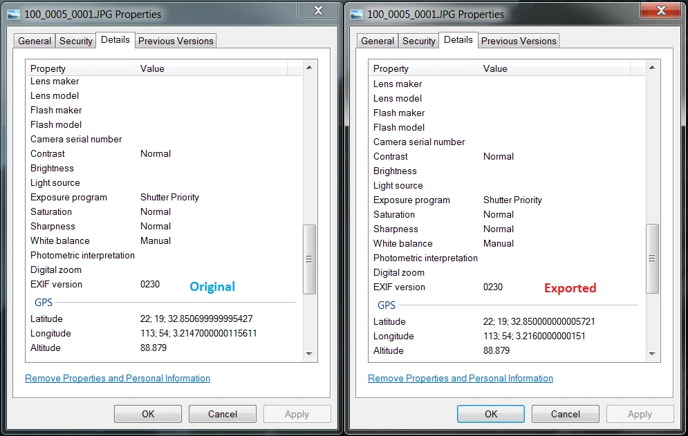
  • February 18, 2019
  • 返信数 3.
  • 1535 ビュー

Hello everyone,

I find that LR doesn't preserve the GPS coordinates in exported JPG, and rounds/truncates them off at 3 decimal places of a second. The original coordinates also come from JPG. I'm aware that we're talking about a difference of only 1 inch, but I use LR to batch process drone pictures for photogrammetry applications so preserving GPS accuracy is essential for me. Is there any solution to this? Copy and pasting isn't practical for me because there are far too many pictures to process. Thanks!

このトピックへの返信は締め切られました。

返信数 3

Participating Frequently
February 20, 2019

This bug has caused me so much grief and so much wasted time! I have been preprocessing geo referenced drone images for photogrammetry survey map work with LR and I had no idea that LR was converting my GPS coordinates to degrees, minutes, seconds and then back to rounded decimals upon exports. I have been assuming that the incorrect GPS coordinates were a result of my drone's GPS.

Adobe PLEASE FIX!

johnrellis
Legend
February 21, 2019

Please add your information to the bug report in the official Adobe feedback forum linked above. Adobe product developers read everything posted there but rarely participate here (a user-to-user forum). 

johnrellis
Legend
May 14, 2019

I'm more than pleasantly surprised -- this is fixed in LR 8.3: Lightroom: Loses precision in exported EXIF GPS coordinates | Photoshop Family Customer Community . That's the fastest that any non-fatal metadata bug has ever gotten fixed.

johnrellis
Legend
February 18, 2019

I did a quick look into this. While LR preserves full precision in the catalog, it exports coordinates to a precision of just 1 part in 10,000 for minutes. That’s equivalent to about 1 part in 167 for seconds, or a little more than 2 decimal digits, or roughly 6”.

It’s a trivial bug to fix but given Adobe’s past track record with such bugs, I think it’s not likely it will get fixed any time in the next many months. So you may want to consider workarounds or using another program. I’m traveling today but tomorrow I might be able to suggest more LR workarounds in addition to the ExifTool suggestion by dj_Paige.

TheDigitalDog
Inspiring
February 18, 2019

johnrellis  wrote

I did a quick look into this. While LR preserves full precision in the catalog, it exports coordinates to a precision of just 1 part in 10,000 for minutes. That’s equivalent to about 1 part in 167 for seconds, or a little more than 2 decimal digits, or roughly 6”.

Bug or just truncating the data for some reason by perhaps design?

Author “Color Management for Photographers" & "Photoshop CC Color Management/pluralsight"
johnrellis
Legend
February 18, 2019

dj_paige  wrote

But ... it costs nothing to output all the available decimal places ... they're already in the database ...

True, but as Andrew has already intimated the engineers probably didn't think it necessary at the time. Remember, the Map module was first incorporated into the application in version 4. Back then, many GPS logging devices available to the general public were limited to an accuracy of yards/metres not inches/cms'


Here's the outline of a workaround that would let you keep using LR: Get the Run Any Command plugin and download and install the free ExifTool.  Using Run Any Command, make a post-processing action for your export preset that runs ExifTool and stores the catalog coordinates for the original photo in the exported photo.  There's a fair learning curve to all this, so if you can't figure it out, let me know, and tomorrow I'll provide a recipe. 

And I'll post a complete bug report explaining the cause and the trivial fix: Use a denominator of 5,000,000 rather than 10,000 in the rational (fraction) that stores minutes in the EXIF coordinates fields, which will give 500 times as much precision.  (You can do better than that using the EXIF standard, but it would require a few more lines of code and a deeper understanding of computer arithmetic.)

dj_paige
Legend
February 18, 2019

I think our metadata expert johnrellis​ needs to comment here. But as far as fixing the problem, a program like Exiftool can, in bulk, copy the GPS from the originals to the exported photos.